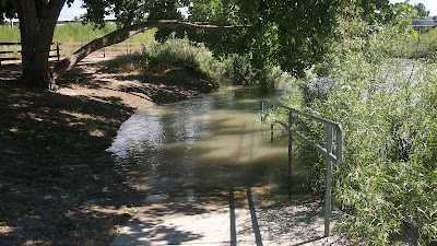
My mom convinced me to post this. She wants to know how bad and there may be some people out there that want to know!
NOTE! Some pictures may look like I posted more than one picture. These are for comparison of diffident days!
6-23-2011 - not much was taken on my first day, I did not venture around as much.
6-25-2011 - Two days later.
7-5-2011 - about a week later. Yay it looks llike it is going down :d
NOTE! Some pictures may look like I posted more than one picture. These are for comparison of diffident days!
6-23-2011 - not much was taken on my first day, I did not venture around as much.
 |
| A pathway to the river bank, about chest deep - Murray city trail. |
 |
| Underpass at 4600s. - Murray city tail. |
 |
| Minor trail overflow - Murray city trail. |
 |
| some flooding on the West Jordan trail |
 |
| A pan of of the river cuting around a river speed bump (I do not know what is called) |
 |
| A flooded underpass |
 |
| other side of the underpass |
 |
| Murray city trail - water level risen |
 |
| 4600s - water lever is higher |
 |
| other side of the underpass at 4600s |
 |
| Ok, I am not going any farther |
 |
| Ok maybe I did but only for a picture back to the path. this got deep fast. this is where I got a roomer that Glendale is flooded worse than this. |
7-5-2011 - about a week later. Yay it looks llike it is going down :d
 |
| Ok here is better picure of that river speed bump. |
 |
| Water went down "just a little" |
 |
| Murray trail - they added sandbags. |
 |
| 4600s - water has gone down! |
 |
| water went down but is leaveing a mess. then on my way home after this. BOOM! I got a blowout on my front tire. |


